Welcome to Business in Great Waters. I’m Jen Holmgren.
For this episode, I was privileged and honored to conduct my first interview on BGW with several of the many incredible people involved with the Cape Ann Museum. In the spirit of full disclosure, I serve on the Cape Ann Museum Community Engagement Committee. More on that in just a minute. In the meantime, I’ll read some info to you from the Cape Ann Museum website, and then we’ll dive right into the interview. I conducted the interview via Zoom, so please forgive the occasional artifact or mouse click – I’m still trying to figure out some of this technology stuff. Still, I think you’ll agree when you hear it: I could listen to Oliver, Miranda, Amanda, and Suzi talk about the Cape Ann Museum all day!
Mission Statement:
“The Mission of the Cape Ann Museum is to foster an appreciation of the quality and diversity of life on Cape Ann, past and present; to further the knowledge and enjoyment of Cape Ann history and art; to collect and preserve significant information and artifacts; and to encourage community involvement with its programs and holdings. In all its activities, the Museum emphasizes the highest standards of quality and seeks to engage the broadest possible audience.“
About:
“The Cape Ann Museum, founded in 1875 as the Cape Ann Scientific and Literary Association, has antecedents reaching back to the early days of the 19th century, when New England was being swept with the spirit of cultural revival…
“After some adjustments to its name and purpose, the Association acquired its first permanent headquarters in the early 1920s, the Captain Elias Davis House (1804). Located on “Captain’s Row” in downtown Gloucester, the Davis House remains part of the present-day Museum. During this same period, the Association acquired the collections of the Gloucester Historical Society and began assembling its own collections in fine art, decorative arts, fisheries and maritime history, books, photographs and other historical artifacts.
“By the 1930s, it became necessary to build a gallery adjoining the Davis House to accommodate the growing collections. The new space also included an auditorium which enabled the Association to provide cultural programming for the community.
“The history of the Association was affected profoundly when Alfred Mansfield Brooks, a Harvard-trained professor of art history, became its president in 1940. His roots were in Gloucester, so after retiring from academia he returned to spend nearly 30 years building the Association’s collections. He believed that Gloucester native Fitz Henry Lane (1804-1865) would eventually hold a preeminent place among 19th century American artists. Brooks began assembling what is now the largest and finest collection of Lane paintings in the country.
“In the 1960s, the growth of the collections prompted yet another expansion, a two-story wing with more galleries and storage space. An entire gallery was devoted to the area’s fishing and maritime heritage.
“The Association began its most extensive expansion program in the late 1980s when it bought an adjacent building. Graham Gund Architects developed a plan with atrium galleries on three levels to link the buildings and with new or renovated galleries in the two buildings. Throughout the 1990s, the Association continued to construct space, more than doubling the size of the Museum.
“The most recent construction provided the Museum with a 1,600 square foot gallery, which features changing exhibitions. The space is dramatic, with a ceiling that rises to 24 feet at its center. A sculpture garden at the Museum’s entrance displays the work of sculptors Albert Henry Atkins, Walker Hancock, George Demetrios, and Ken Hruby.
“In 2007, the Museum’s Board voted to adopt the name Cape Ann Museum, with the accompanying tagline: Art | History | Culture. The new name was chosen to more accurately describe the focused, but expansive nature of the Museum’s mission and to strengthen the Museum’s commitment to the people of Cape Ann and to the preservation and presentation of its rich traditions of art, history and culture.
“Today, the Museum is a vibrant cultural center, which includes galleries, an auditorium, a library/archives, a children’s activity center, two sculpture gardens and two historic homes.”
“As a steward of the art, history, and culture of Cape Ann, the Cape Ann Museum is committed to accurately and fully representing the lived experiences of all those who have been part of this region’s history and are part of its story today. Through our ongoing scholarship and community engagement, the Museum strives to develop an understanding and appreciation of Cape Ann’s continuously unfolding narrative, both past and present, and commits to representing it in our permanent collection, archives, exhibitions, and programs as well as in our communications and workplace.
“The effort to become an equitable and inclusive organization will always be in process and the Museum will maintain this Commitment as a living document that is core to our ongoing growth and relevance. We recognize that historically museums have not felt welcoming and relevant to all communities. The Cape Ann Museum aims to shift that paradigm through our commitment to diversity, equity, inclusion, and accessibility by exploring deeply what those terms mean to our community and putting them into practice across all aspects of the Museum. We follow the definitions of Diversity, Equity, Accessibility, and Inclusion put forward by our colleagues at the American Alliance of Museums.
“The Cape Ann Museum Community Engagement Committee, comprised of staff, board, volunteers, and community stakeholders, is currently developing a set of Action Steps that will be revisited annually to ensure that the Museum is continuing to work towards these goals. To become a truly equitable and inclusive organization, visitors of all backgrounds must not only feel welcomed but also be able to relate to our programs, people, and collections. We are actively seeking input from community members and museum visitors on how the Cape Ann Museum can become a more diverse, equitable, inclusive, and accessible organization.“
Please visit the BGW blog, bgreatwaters.com, for a transcript, pictures, and more info. That’s the letter b, then great waters, all one word.
If you feel so moved, please head over to my Patreon page: www.patreon.com/bgw. There you’ll find special perks for monthly supporters including merch. If you aren’t able to sign up for a Patreon at this time but would like to support BGW, please tell your family and friends about us, and if you can, leave a positive review in your podcast app. Positive reviews boost visibility for BGW, or any other podcast you listen to, and us creators really appreciate it because it helps us bring you more content.
Thank you for listening, and thank you for your support.
Welcome to Business in Great Waters. Thanks for tuning in;. I’m Jen Holmgren.
Here on the North Shore, as in other areas of the United States and the world, a severe drought has gripped us for the majority of this summer. Local fire departments, the National Guard, and the Mass. Bureau of Forest Fire Controls and Forestry have battled wildfires in Gloucester, Rockport, and now in the Lynn Woods Reservation and Breakheart Reservation in Saugus. Thankfully, the Gloucester fire has been extinguished. Hot spots continue to flare up in Rockport. The Lynn Woods fires just started a few days ago, scattered, but taking up a total of 26 acres. Lynn Woods is the second largest municipal park in the United States and was founded in 1881. Breakheart is part of the Massachusetts State Park system, the Department of Conservation and Recreation. As of this episode’s recording, I am thankful to report no lives have been lost. Dedicated, amazing firefighters and first responders have been working overtime to keep the blazes under control, blazes which have come perilously close to people’s houses and thickly settled neighborhoods. In our corner of Gloucester, varying winds blow the smell of smoke into our house. Our grass is brown and scorched. We have given up on our vegetable garden. Even the weeds seem thirsty, except for the crab grass.
We are used to unpredictable weather here in New England, but I don’t recall a time in my 42 years when we ever went this long without a good rainstorm. I mean, it’s been weeks. We’re in what many call a “micro-climate.” Because of our position on the coast, stuck out in the middle of the Atlantic Ocean, we feel the benefit of more moderate temperatures than those North Shore cities and towns closer to Boston. Also because of this, though, we have seen some neighborhoods get rain while others stay dry. When it does happen, it hasn’t been much rain, maybe a few minutes to a few hours. Nowhere near enough. I keep checking the Cape Ann Weather page, run by Rockport’s Chris Spittle, for the most accurate reporting. We are all holding our breaths waiting for the rain.
As I’ve said several times, I have some pretty exciting plans for upcoming episodes. Ideas flow, and I begin writing. I double-check my sources. I have made amazing connections. You listeners have encouraged and inspired me, and I know I am on the right path.
Today, though, I’m feeling a little stuck. And a little sad. To help cheer us all up, I’ll throw this tidbit out there – the City of Gloucester has worked for years to help mitigate the effects of climate change. We are a Massachusetts Designated “Green Community” and have been for 12 years and counting. Gloucester is a coastal city, and we have all seen what is happening with the tides. With the weather. With pollution. A lot of work has been and is being done to combat the effects of all these things and to help prevent them from getting worse.
In particular, I want to highlight the good work of the City’s municipal Clean Energy Commission. There are amazing things the volunteers on this Commission have done, in conjunction with our City departments and government, to help lower our collective carbon footprints. Municipal buildings have had upgrades to boilers and HVAC systems. Building “stretch codes” have been adopted from the state building code for new construction projects so that new buildings are more energy efficient. A small point of contention has been the installation of LED streetlights around the city. They are very bright. But, they use far less electricity than their traditional counterparts. About 9 years ago, the city permitted 3 large wind turbines to produce energy at Blackburn Industrial Park to help offset energy consumption. The turbine owned by Applied Materials, one of our largest employers, unfortunately lost a blade a couple of weeks ago. I’m not sure when a new one will be reattached. The other two turbines are still spinning. They feed into Gloucester’s power grid under a public-private partnership. The energy they produce generates hundreds of thousands of dollars a year for the city in buy-backs from National Grid, our power company.
Plans to further resilience against climate change are being discussed and implemented as we speak. We are all – all of us in the world – stakeholders in this because it affects all of us. Especially our children, our flora, our fauna, and our future as a species on this planet.
The Wreck of the Hesperus
It was the schooner Hesperus,
That sailed the wintry sea;
And the skipper had taken his little daughter,
To bear him company.
Blue were her eyes as the fairy-flax, 5
Her cheeks like the dawn of day,
And her bosom white as the hawthorn buds,
That ope in the month of May.
The skipper he stood beside the helm,
His pipe was in his mouth, 10
And he watched how the veering flaw did blow
The smoke now West, now South.
Then up and spake an old Sailòr,
Had sailed to the Spanish Main,
‘I pray thee, put into yonder port, 15
For I fear a hurricane.
‘Last night, the moon had a golden ring,
And to-night no moon we see!’
The skipper, he blew a whiff from his pipe,
And a scornful laugh laughed he. 20
Colder and louder blew the wind,
A gale from the Northeast,
The snow fell hissing in the brine,
And the billows frothed like yeast.
Down came the storm, and smote amain 25
The vessel in its strength;
She shuddered and paused, like a frighted steed,
Then leaped her cable’s length.
‘Come hither! come hither! my little daughtèr,
And do not tremble so; 30
For I can weather the roughest gale
That ever wind did blow.’
He wrapped her warm in his seaman’s coat
Against the stinging blast;
He cut a rope from a broken spar, 35
And bound her to the mast.
‘O father! I hear the church-bells ring,
Oh say, what may it be?’
‘’Tis a fog-bell on a rock-bound coast!’—
And he steered for the open sea. 40
‘O father! I hear the sound of guns,
Oh say, what may it be?’
‘Some ship in distress, that cannot live
In such an angry sea!’
‘O father. I see a gleaming light, 45
Oh say, what may it be?’
But the father answered never a word,
A frozen corpse was he.
Lashed to the helm, all stiff and stark,
With his face turned to the skies, 50
The lantern gleamed through the gleaming snow
On his fixed and glassy eyes.
Then the maiden clasped her hands and prayed
That savèd she might be;
And she thought of Christ, who stilled the wave, 55
I am dedicating this episode to Helen Garland, who passed away earlier this week at the age of 95. She was an indomitable spirit and an incredible thinker who influenced and helped to improve the world locally and abroad, whether it was working with Margaret Mead or championing local causes such as the foundation of Awesome Gloucester – more on that in a little bit. Helen and her husband, author Joe Garland, who passed away in 2011, were the embodiment of the spirit of Gloucester. We are all grateful for, and better for, the vast legacies they have left.
Thanks to Robb F, Jeanine H, Brian K, and Edward K for your input on other TV shows and movies made in Gloucester – you helped me so much! These friends of mine told me the following: the very first episode of the show Route 66 was filmed here! 1998’s The Love Letter, starring Ellen DeGeneres and Tom Selleck, was filmed in Rockport. The Amazing Race started here one season. Scenes from the show Bewitched were filmed here. The Crucible, starring Daniel Day-Lewis, was filmed on Hog Island also known as Choate Island in Essex. And The Witches of Eastwick, starring Jack Nicholson, Cher, Susan Sarandon, and Michelle Pfeiffer was filmed in Ipswich at the Crane Estate.
Today, I’m going to focus on West Gloucester, the area west of the Annisquam River. I’m planning to do an episode or two of Magnolia soon, but today is just feeling like a West Gloucester day. Buckle up – this is likely going to be my longest episode yet.
INTERLUDE SHORT
Gloucester’s population usually hovers between 28,000-30,000, with more people being here in the summertime. The city is currently divided up into 5 municipal wards according to population, and further into 2 separate precincts per ward. The population in each precinct is calculated at a little less than 3,000 permanent residents each. West Gloucester is in Ward 5. It is precinct 2, sharing Ward 5 with Magnolia in Precinct 1. West Gloucester occupies the largest area of land in Gloucester. A huge amount of that is protected in the form of green space, watershed, or marshland. I love every part of Gloucester for different reasons, but I’m particularly keen on West Gloucester.
So if you remember, in Episode 2 I talked about land grants. 31 pieces of land in West Gloucester were deeded to Gloucester citizens in the 1600’s. You might also remember I talked about West Gloucester (and I’m assuming Magnolia) residents being obligated to take a ferry across the Annisquam to get to the meeting-house every week. According to the West Gloucester Trinitarian Church website, each resident had to pay a penny to cross, or two pennies if they came with a horse. If you are familiar with Gloucester, Ferry Street next to Addison Gilbert Hospital leads to a public landing. It was this public landing the residents of West Gloucester used to disembark from the ferry and trek the rest of the way to Meetinghouse Green.
Well, this got pretty tiresome, especially considering all the land at the residents’ disposal and the expense of the ferry toll. I turned to my trusty copy of Pringle’s History of Gloucester for the following brief information:
“In 1710 the inhabitants residing at the west parish petitioned the town for land in their precinct upon which to erect a meeting house. As has been shown, they were obliged to travel from three to five miles via the ferry to attend religious services. In March, 1716, they petitioned to be set off as the second parish and in June of the same year they were incorporated as such by the General Court. They erected a meeting house in a commanding spot and November 28, 1716, Rev. Samuel Tompson, of Newbury, a graduate of Harvard in 1710, was settled as their pastor. He married Hannah Norwood by whom he had several children and died December 8, 1724, aged 33. He was laid to rest in the old burial place of the parish…”
To elaborate further, Babson’s History of Gloucester reports on the first petition denial in 1710. ”The petition was referred to a committee of five to consider and report what was best to be done concerning it. They did not report in favor of the petitioners; but they made a recommendation, which was agreed to by the town, that the selectmen, in engaging a schoolmaster for the people of that section of the town, should endeavor to procure a man, who, in the judgment of their reverend pastor, was suitably qualified to preach to them on the Lord’s Day, for about three or four months in the winter season, in some convenient place to be designated by the inhabitants. The town voted to pay the schoolmaster out of the town-treasury, and to continue the arrangement three years.”
So the West Parish residents hired Samuel Tompson in 1712. They provided him with a salary, and he served them for another 4 years when another petition was filed, and then until his death. Reverend Tompson’s gravestone is now mounted on the wall at the West Gloucester Trinitarian Church along with other notable West Parish inhabitants. The parishioners continued to meet, and continue still, even after the old building finally needed to be taken down. The West Gloucester Trinitarian Congregational Church on Route 133 is the modern building and congregation continuing the West Parish traditions, including making a yearly trek to the old Second Parish site for a sermon – required for it to keep the charter valid.
Despite the establishment of the second parish, the ferry continued to run, as it saved time to cross the river rather than using the Cut bridge. But who ran the ferry? According to Babson, Samuel Hodgkins was hired to be the ferryman in July of 1694. According to all of my sources, the Hodgkins family ran the entire ferry operation for over a hundred years.
Although it has not been possible for quite some time to access the original Second Parish site by car or carriage, taking the 8/10 of a mile trail is a lovely and fairly easy hike. The area is run by the nonprofit Essex County Greenbelt. Here is their mission: “Greenbelt protects natural land and working farms across Essex County forever, helping to conserve healthy ecosystems, clean water, local food supplies, scenic landscapes and free, accessible places for all to benefit from nature.” Check out their website, ecga.org, in the show notes. It’s well worth visiting any or all of their properties.
What else makes West Gloucester unique?
An important West Gloucester story is that of Robin Freeman, a slave who bought his freedom from Captain Charles Byles.
Captain Byles was born in 1700. He lived in a home he’d purchased from his father on Essex Avenue (Route 133), which has since been lost to the ages. His family owned a tavern – Byles’ Tavern – right next to Beechbrook Cemetery, about 1/4 mile from state highway Route 128 and about 1/2 mile from the current Trinitarian Congregational Church. Captain Byles commanded a company during the French and Indian War at the Battle of Louisbourg in 1745. He also owned a slave named Robin or Robert Byles. The following information from Captain Byles’s account book is courtesy of the Cape Ann Museum archive: ”In 1768 or 1769, Robin [Freeman] bought his freedom from Captain Charles Byles (1700-1782), who concluded the financial negotiation in his account book with the words “Robing is free.” This refers either to the Robin Freeman who later appeared in the Joseph Moore (1763-1845) account book or to Robin Freeman the son of Prince and Robin Byles, who married in bondage in 1715. In his will of 1781, Byles left “Robin former negro servant 40s[hillings].” Captain Byles died in 1782.
The following information is from the Cape Ann Slavery and Abolition Project: Robert Freeman Sr. rented a home from another West Gloucester farmer and landowner, John Gotham Rogers, and raised his family there. Robert Freeman, Jr. went on to purchase and establish a family home at 302 Essex Avenue, where they lived for generations until the last member of the family, Harriet “Hattie” Johnson, passed away in 1931. The building was originally a sawmill built by Jacob Davis in 1709. It became a hostel and tavern where, rumor has it, a case of smallpox broke out because one guest was unwittingly carrying the virus in his hat. After Hattie Johnson passed away, the building was by turns The Stagecoach Inn and a private home. The house is now the headquarters of Wellspring, a nonprofit agency serving families and adults on the North Shore, helping them to achieve employment and financial security through stable housing, education, job training and career readiness. Check out the Wellspring House website in the show notes.
Across the street, there’s a Little Free Library – founded by myself with support from the neighborhood, our local hardware store The Building Center, the Gloucester High School vocational program, the City of Gloucester, and an Awesome Gloucester grant – a picnic area, and a public landing named after shellfish warden Stubby Knowles. More on him in a minute. It’s very pleasant to stop and sit a spell, especially if you feel like grabbing an ice cream or a cold drink from the convenience store across the street. Awesome Gloucester is a chapter of the Awesome Foundation, and encourages and supports projects intended to add Awesomeness to Gloucester in any of the following areas: (1) innovation in maritime related industry and economy, (2) preservation of maritime heritage and culture, and (3) community togetherness and appreciation. Helen Garland helped found the Gloucester chapter of the Awesome Foundation. To date, they have awarded $138,000 in micro grants to over 125 worthy causes. I’ll leave a link to their page – and to the Building Center – in the show notes.
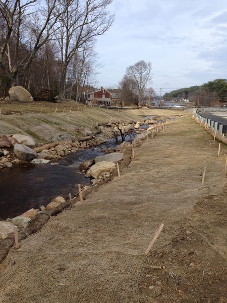
Right behind the Freeman House, as it is still affectionately known, there is a pleasant, babbling brook. It is called Alewife Brook, and it is next to the water treatment plant at the corner of Magnolia Ave and Essex Ave. The public is free to visit this site. Parking behind the plant can be a little tricky, but it’s worth the reward. You can sit or stand and observe the brook on a platform built by a local Eagle Scout. You can see where the alewife counters observe the fish swimming upstream to spawn starting April 1. But it didn’t look this way for decades.
Back in the 1960’s, Gloucester shellfish warden, West Gloucester Native, and tremendous environmental steward, Stubby Knowles, emphasized the importance of installing a fish ladder when the original water treatment plant was built to replace the pumping station. The plant was built right over the old stream in 1969, and Stubby was adamant that a fish ladder be built to help preserve the herring population who spawn at the Lily Pond off Laurel St. There was little to no knowledge of how to build an artificial fish ladder to replicate what the fish had been using in nature for millennia, so the City built the next-best thing – one made of concrete slabs. It was better than nothing, but it provided no protection from the elements and no place for the fish to rest. At least it was there! 46 years passed between the construction of the fish ladder and when the brook was restored.
Dozens of people have been doing the fish counts, here and in other areas around Essex County, for decades. Because of their tireless work, the city of Gloucester was able to partner with NOAA, the National Oceanic and Atmospheric Administration, and also secured funding from the City’s Community Preservation Committee, to create this beautiful fish ladder and habitat. Now the alewife have a natural stream to make their run to the Lily Pond and mate, and then swim back down the brook to Little River, the tidal river which feeds into the Annisquam. This would have been far more difficult to achieve if it had not been for Stubby Knowles’s advocacy. Now, the food chain is stronger, our landscape is even more beautiful, and we’ve gained a deeper understanding of environmental science and stewardship we can learn and teach our children. Please see the show notes for a link to the PDF application of the Little River fish ladder restoration project, including images and important data.
A view of the Freeman House and Little River beyond after restoration project was just completed; 2016. Photo c. Jen Holmgren
Want to get around West Gloucester but aren’t sure where to start? By vehicle or by bike, you could try out The Little Heater.
What the heck is that? According to Gloucester lore, it is more or less a scalene triangle consisting of major roads surrounding land including Ravenswood Park, Fernwood Lake and some smaller bodies of water, and Bond Hill. Bond Hill is a small hill with a reservoir and some homes abutting Ravenswood Park. Fernwood Lake had an historic ice house back in the days before electricity. I’ll talk about Ravenswood shortly.
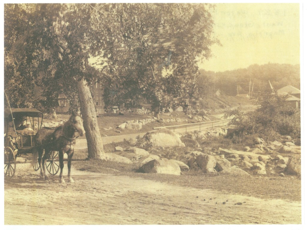
According to celebrated local historian and author Joseph Garland in his book “The Gloucester Guide: A Retrospective Ramble” published in 1973 for Gloucester’s 350th anniversary, “The junction of Magnolia and Western avenues was one corner of ‘The Little Heater,’ when the hoss was boss, a rough triangle of three roads which was far and away the most popular drive for the smart turnouts, carriages, buggies, pacers, teams, matched pairs and horseback riders of the resort era. No one is quite sure how Magnolia Avenue to Essex Avenue at Little River to Western Avenue at Kent Circle and back to Magnolia Avenue, or the reverse, got its name. Some say because it warmed up your horses, others because it was shaped like a snowplow called a heater, others because it resembled in outline a chunk of cast iron, a heater, which the housewife heated on the stove before dropping it in the hollow of her flatiron, and still others because it was a ‘heat’ for the gents who savored racing their fast trotters around it. There was a ‘Big Heater,’ too, a longer trot along Essex Avenue to Essex, south on Southern Avenue and School Street to Manchester, returning to Kent Circle by Magnolia Avenue.”
The intersection of Magnolia Avenue (in the background) and Essex Avenue (in the foreground). Pictured in this sepia-toned image, taken circa 1890-1900, is a family in a horse-drawn carriage. They are turned toward Essex, perhaps having just finished a jaunt around The Little Heater or a stay at one of Magnolia’s grand hotels. In the background on the right is the old water-pumping station, which was replaced by the new water treatment plant in 1969. The houses are still there, though not very easy to see in the background. Some of the granite boulders are still in the exact same spots. – Image courtesy of Sarah Dunlap, Gloucester Archives Committee.
This rough triangle’s apex is at the corner of Essex Avenue and Magnolia Avenue, right next to the Freeman House. If you travel south down Route 133, you’ll come to Kent Circle at Stacy Boulevard. Consider, though, stopping at the Causeway or the Cape Ann Marina for lunch, White Farms for ice cream, and a movie at Gloucester Cinema.
Kent Circle is the intersection of Route 133 and Stacy Boulevard, the second corner of the triangle. You’ll pass Stage Fort Park (or, if you want to go through it, turn left at the baseball field onto Hough [pronounced “Huff”] Avenue). Keep going, following Western Avenue, passing landmarks along the way. Which landmarks? On the left, on a hill and behind a fence, is the Cardinal Cushing estate. The Boston Archdiocese unwittingly sold it to the Unification Church – yes, the “Moonies” – through an intermediary in the late 1970’s. You can bet I’ll expand on that topic in a future episode!
Further down on the left, you might catch a glimpse of Freshwater Cove and Dolliver’s Neck through the trees. This area marks the entrance to Gloucester Harbor on the Southwest side and is simply stunning, dotted with stately private homes and marsh land. Across the street on the right, you’ll pass a shoulder where you might stop to gaze at Buswell Pond. This pretty body of water is privately owned, so please no swimming, boating, etc.
Staying on Western Avenue, you’ll drive by several very old homes. Now, this is not to say there are not other old homes along this route. I’ll get into as many old homes as I can during this series. However, I always find myself paying more attention to the homes along this end of Western Avenue because of all the hustle and bustle that’s usually happening near the Boulevard. Please also note, unless otherwise specified, these are private homes. I just find them so intriguing, especially if they happen to have a historic plaque with the name of the original owner!
Further up on the right, you’ll eventually happen upon Ravenswood Park. The Trustees of Reservations own this immense property, 600 acres in all, with trails in the woods, hills, swamps, deciduous and evergreen trees, granite boulders, and sweeping views of the harbor. Samuel Sawyer, a local philanthropist, purchased the land and bequeathed it to the City, and the Trustees purchased it in 1993. The Trustees write: “Ravenswood Park offers 600 acres for solitude and quiet contemplation, a testament to its founder’s conservationist philosophy. Nineteenth-century businessman and philanthropist Samuel Sawyer purchased woodlots, old pastures, and swamp near his home on Freshwater Cove, and upon his death left the more than 26 parcels to be turned into a park named Ravenswood, after the castle in Sir Walter Scott’s The Bride of Lammermoor. Whether you prefer to surround yourself with snow-covered hemlocks, experience spring emerging in a burst of color and aroma, or escape the summer heat, you’ll find refuge here.”
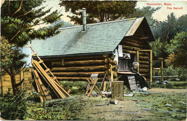
Another fascinating character of West Gloucester was Mason A. Walton, the Hermit of Ravenswood.
After the tremendous personal loss of his wife in childbirth followed by the baby a few hours later, Walton went to work in Boston but developed a severe respiratory infection. He decided to move to Gloucester, where he built a cabin at Ravenswood in 1884 and, giving Henry David Thoreau a run for his money, commenced spending many years studying the wildlife there. He wrote several books, including “The Hermit’s Wild Friends, or 18 Years in the Woods.” He was also a writer for Field and Stream magazine and attracted thousands of visitors a year to the hermitage. Unfortunately, his home burned to the ground in the late 1940’s. There is still a tablet at Ravenswood denoting where he lived, placed there in 1933 by the Gloucester Women’s Club. Check out the blog, where you can see a vintage postcard picture of Walton at his house courtesy of the Sawyer Free Library Digital Heritage site.
Once you leave Ravenswood, continue on Western Avenue. There are walking paths everywhere maintained by the Cape Ann Trail Stewards, a volunteer-run coalition of Cape Ann residents, and there are ways to get from Ravenswood all the way to the shoreline if you plan ahead of time. But back to the Little Heater: If you visit at the right time, you’ll see the gates at the soccer fields are open. These fields are actually capped landfills. Please park in the designated parking areas and take in the gorgeous view – but be mindful of the Canada geese and their droppings.
Keep going. You’ll see woods, houses new and old, another baseball field, and then it’s time to turn right onto Magnolia Avenue. You’ve made it to the third corner of the Little Heater!
Magnolia Avenue is primarily residential, athough there is access to the Kondelin Road Industrial Park from it. Watch out: in the wintertime, because of its proximity to the swamp, the road can become choked with ice and is thickly settled in places. Depending on where you are on the road and the time of year, it is possible to see the Lily Pond and the MBTA train tracks down the hill on the left as you make your way back to Route 133.
Eventually, you’ll go under a train bridge. Keep going, and you’ll find yourself back at the water treatment plant! That was a fun journey.
There is still so much I want to tell you, but that will come another time. Right now, it’s time for Not-So-Clear Facts.
TRIVIA
Before 1623: the Native American name for Cape Ann was Wingaersheek.
1704 – 1705: Landlady Judkins was paid for entertaining town fathers. I’m assuming at a tavern.
1716: there was a great darkness, and the air was filled with smoke.
In 1836, a shoe dealership was established.
1919: First municipal garbage collection.
1963: 2 earthquakes at sea jolted Cape Ann
OUTRO
Please visit the BGW blog, bgreatwaters.com, for a transcript, pictures, and more info. That’s the letter b, then great waters, all one word.
If you feel so moved, please head over to my Patreon page: www.patreon.com/bgw. There you’ll find special perks for monthly supporters including merch. If you aren’t able to sign up for a Patreon at this time but would like to support BGW, please tell your family and friends about us, and if you can, leave a positive review in your podcast app. Positive reviews boost visibility for BGW, or any other podcast you listen to, and us creators really appreciate it because it helps us bring you more content.
Thank you for your support.
Books:
History of the Town of Gloucester, Cape Ann, including the Town of Rockport; John J. Babson, c. 1860; republished 1972
The Gloucester Guide: A Retrospective Ramble; Joseph E. Garland, c. 1973
History of the Town and City of Gloucester, Cape Ann, Massachusetts; James R. Pringle, c. 1892
Gloucester, Massachusetts Historical Timeline: 1000 – 1999, compiled by Mary Ray, edited by Sarah V. Dunlap, assisted by Gloucester Archives Committee: Priscilla Anderson, Ann Banks, Stephanie Buck, Kathleen Cafasso, Lois Hamilton, Priscilla Kippen-Smith, Myron Markel, John Quinn, Alan Ray, Elaine Smogard, Janie Walsh, Natalie Whitmarsh. c. 2002, Mary Ray.
Since we are in the height of summer here in Gloucester, Episode 3 will be a briefer episode. Maybe it’s not even an episode. Maybe it’s more like a bonus. That’s what I’ll do. It’s a bonus episode. There will be a slight delay before the next one comes out, but I’ve got several irons in the fire. It’s going to be a busy and productive few months for BGW! I can’t wait to share with you!
Anyway, this bonus episode is basically just a list of every movie or TV show I could find made or set in Gloucester or on Cape Ann, whether partially or in full. Most of these I found on Wikipedia or remembered they were done here. The first ones I found on the Good Morning Gloucester blog.
In 1920, the Fox Studios lost film “Bride 13″‘s final scene was shot on Good Harbor Beach. I found more information about this movie, including pictures, on the Good Morning Gloucester blog. GMG has been around for years now. Joey Ciarametaro and the crew are always a really good time, and GMG is a good source for so many of the things happening here, including where to eat, what to see, and just what’s going on. I’ll leave the link in the show notes. Check it out!
1923’s The Silent Command, a Naval propaganda film from the silent film era, was also partially filmed on Good Harbor Beach. It starred Bela Lugosi in his American cinema debut. If you’re curious about it, The Silent Command is free for download on the Internet Archive, as it has now entered the public domain. The link is in the show notes. And some of the music I’m using in this episode is from The Silent Command.
1937’s Captains Courageous was filmed in Gloucester. Based on Rudyard Kipling’s famed 1897 novel, it starred Spencer Tracy, Lionel Barrymore, Mickey Rooney, and John Carradine, among others. Spencer Tracy won the Academy Award for his work in the film.
The Russians Are Coming, the Russians Are Coming , the 1966 comedy, wasn’t filmed here. It takes place on a fictional Gloucester island but was filmed in Mendocino, California. I just included it because it’s a classic, though I still have yet to see it. It stars Carl Reiner, Alan Arkin in his first film role, Eva Marie Saint, Jonathan Winters, and John Ford. According to Wikipedia, the The film depicts the chaos following the grounding of the Soviet submarine Спрут (pronounced “sproot” and meaning “octopus”) off a small New England island during the Cold War. It’s based on the 1961 novel “The Off-Islanders” by Nathaniel Benchley. I mean, for Carl Reiner and Alan Arkin alone, why haven’t I seen it yet?
1982: Author! Author! starring Al Pacino also had scenes shot on Good Harbor Beach.
Good Harbor Beach after a brief rainstorm, 7/14/22. In the foreground, there are some large rocks in the sand. People are walking on the beach, but it is not crowded. In the background, the houses and hills of Brier Neck are on the left, Thatcher Island with Twin Lights is in the middle, and on the right, Salt Island appears to have a rainbow touching it and going right up into the clouds. The other end of the rainbow is just barely visible between Thatcher Island and Brier Neck.
In 1984’s The Bostonians, starring Jessica Tandy, Vanessa Redgrave, and Christopher Reeves, oceanfront scenes were filmed on rocks at Rafes Chasm Park, off Hesperus Avenue in Magnolia.
One Step Beyond, a TV show which aired from 1959-1961, set episode 19, “The Captain’s Guests”, on “Cape Ann Road,” so it was set in Gloucester, but I don’t think it was filmed here.
1990 film Mermaids, starring Cher, Winona Ryder, Bob Hoskins, and Christina Ricci, had scenes shot in the Magnolia area of Gloucester and in downtown Rockport.
1992’s The Good Son, starring Macaulay Culkin and Elijah Wood, was filmed in Gloucester and other Cape Ann communities.
The short-lived 1996 sitcom Townies, starring Molly Ringwald, Lauren Graham, and Jenna Elfman, was set in Gloucester.
The Perfect Storm, released in 2000 and based on Sebastian Junger’s 1997 book of the same name, was filmed and set in Gloucester. It starred George Clooney, Mark Wahlberg, Diane Lane, John C. O’Reilly, William Fichtner, and Mary Elizabeth Mastrantonio.
Moonlight Mile, released in 2002 and starring Dustin Hoffman, Susan Sarandon, and Jake Gyllenhaal, was filmed almost entirely in Gloucester, with some shots in Marblehead. It took place on Cape Ann as well.
Portions of Stuck on You, released in 2003, were filmed in Gloucester and in neighboring Rockport. (The rink scenes were filmed at O’Maley Middle School, which continues to offer public use of its awesome ice skating rink.)
Released in 2007, Polis is This: Charles Olson and the Persistence of Place is a one-hour documentary about the poet Charles Olson which the Boston Phoenix called “the best film about an American poet ever made.”
The Women, released in 2008 and with an all-star cast including Annette Bening, Meg Ryan, Eva Mendes, Debra Messing, and Kate Hudson was partly filmed in Annisquam.
The Gloucester 18 is a 2010 documentary film that investigates the Gloucester pregnancy pact, and was filmed entirely in Gloucester.
The 2010 Adam Sandler movie Grown Ups was filmed largely in Gloucester and Essex.
Clear History, released in 2013 with an all-star cast including Larry David, Kate Hudson, Jon Hamm, Michael Keaton, Eva Mendes, Amy Ryan, and JB Smoove, takes place on an island in New England, but was filmed in Gloucester and around Cape Ann.
Manchester by the Sea, starring Casey Affleck and Michelle Williams, was released in 2016. Much of this movie was filmed in Gloucester.
Adam Sandler’s Hubie Halloween, released in 2020, was filmed in Gloucester and neighboring communities.
And finally, the Academy Award-winning 2021 film CODA, starring Emilia Jones, Eugenio Derbez, Troy Kotsur, Ferdia Walsh-Peelo, Daniel Durant, and Marlee Matlin, is based in Gloucester. Much of it was filmed here or in Beverly, MA.
Fun piece of trivia: Maila Nurmi, also known as Maila Elizabeth Neimi, was the actress famous for playing Vampira. She was born in Gloucester, her father a Finnish immigrant and her mother a Finnish-American. For a time, she did circulate a rumor she was born in Finland to a famous athlete. The Finnish community in the Gloucester neighborhood of Lanesville, where Neimi lived when she was a young girl, also figures big in my family history. All that is on the docket for future episodes.
In the meantime, Happy July!
Please visit the BGW blog, bgreatwaters.com, for a transcript, pictures, and more info. That’s the letter b, then great waters, all one word.
If you feel so moved, please head over to my Patreon page: www.patreon.com/bgw. There you’ll find special perks for monthly supporters including merch. If you aren’t able to sign up for a Patreon at this time but would like to support BGW, please tell your family and friends about us, and if you can, leave a positive review in your podcast app. Positive reviews boost visibility for BGW, or any other podcast you listen to, and us creators really appreciate it because it helps us bring you more content.
Thank you for listening, and thank you for your support.
Welcome to Business in Great Waters. I’m Jen Holmgren.
I want to start off my second episode by just saying thank you. Thank you to my family, and my friends, and the people I haven’t met who decided to download and listen to my podcast. I am grateful for each and every one of you, and I can’t wait to bring you more interesting info about Gloucester. I hope you enjoy it.
In this episode, I’ll delve deeper into the founding of the town of Gloucester – not the City, that came in 1873 – some trivia, some minutiae, and a look into more of the building blocks of New England and modern America.
In October of 1641, Messrs. Downing and Hathorne, deputies from Salem, were appointed to assign lots of land after the General Court drew the boundaries of Ipswich, Cape Ann, and Manchester. Residents settled on the name Gloucester, naming it after the ancient seaside city of Gloucester, England.
Here’s a piece of trivia: I mentioned a man by the name of Hathorne. The Hathorne family has a storied past in Danvers and Salem. That’s Hathorne, spelled H-A-T-H-O-R-N-E. Deputy Hathorne was William Hathorne. He was the first of his family on American Soil. For those of you familiar with the Salem witch trials, William was the father of Judge John Hathorne, who presided over many of those trials in what is now Danvers. History has shown Judge Hathorne was an enthusiastic participant in the Salem witch trials, unrepentant for his actions sending so many innocent people to their deaths. Nathaniel Hawthorne, the author of books such as “The Scarlet Letter” and “The House of the Seven Gables,” was a patrilineal descendant of these men. It is possible he added the W to his name to distance himself and his legacy from the heartbreak and hysteria of the Salem witch trials.
In the seventeenth century, land grants were issued to individuals who were determined to be natives of Gloucester, and had reached the age of majority, and who were capable of the rights and duties of citizenship. Important to note: all grantees had English surnames. Most were men; some were women. 82 lots were assigned east of the Cut, and 31 were assigned in West Gloucester and Magnolia.
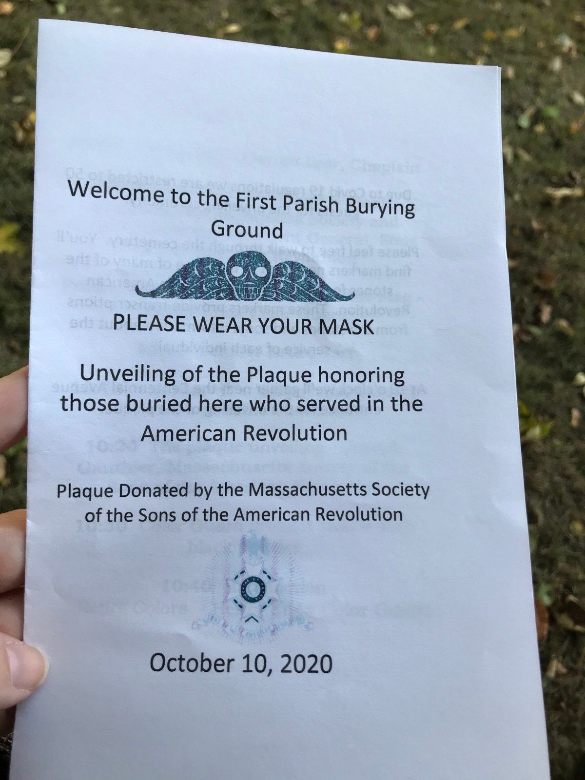
When I recorded the first episode, I touched on the establishment of the First Parish Church. The first meeting house, with sermons led by Richard Blynman, was in an area of downtown Gloucester called Beacon Hill. According to Pringle’s History of Gloucester, published in 1892, “A meeting house was erected as early as 1633. …This was a small log structure. Hard by a half acre of the field in that vicinity in 1644, was reserved for a burial ground, and here all that was mortal of the early settlers was laid to rest. This spot is, without doubt, the site of what is the Bridge street burial ground.” Bridge street is not currently a street in Gloucester, so I visited the Essex County Registry of Deeds website to clarify. Bridge Street in the 1890’s was what Centennial Avenue is now, and “Ye Oldest Burial Place,” as it is marked, is now called the First Parish Burial Ground. Before Bridge Street, it was named “Burial Ground Lane.” I am sure it was named Bridge Street after the Boston and Maine railroad bridge was constructed nearby.
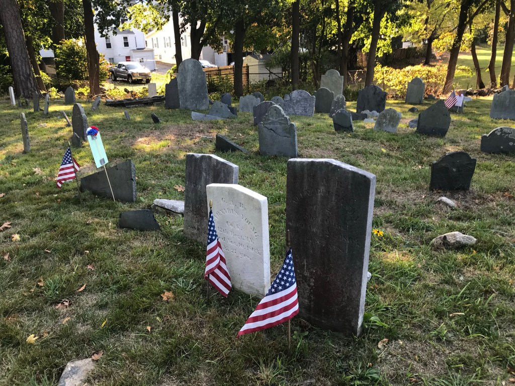
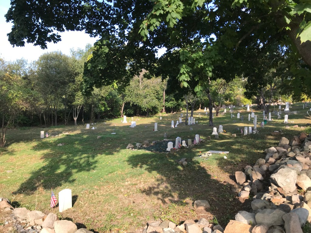
From Cape Ann Atlas, 1899, Essex County Registry of Deeds
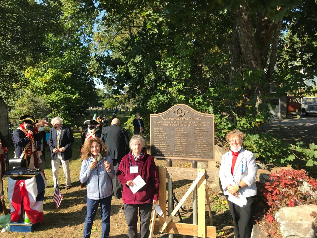
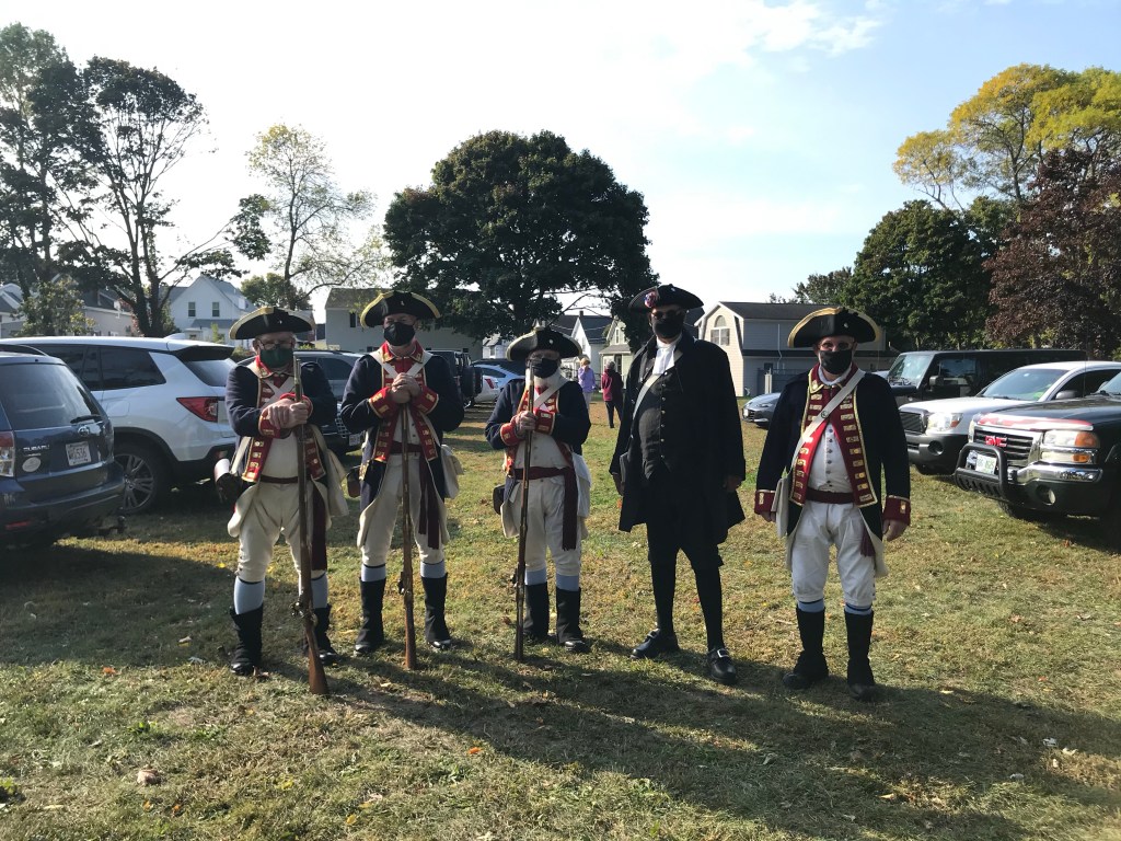
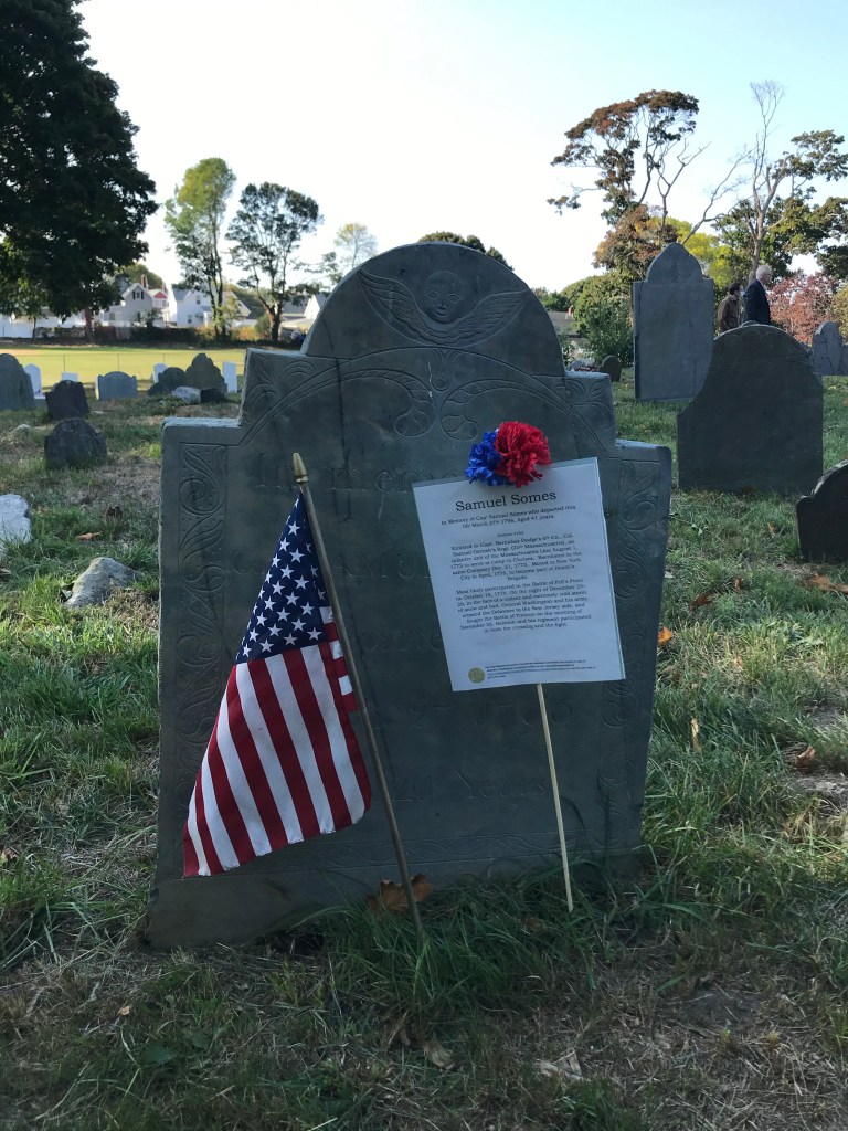
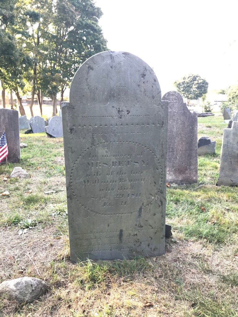
The volunteers of the City of Gloucester Cemetery Advisory Committee and the Clark family have taken on the immense task of restoring and maintaining First Parish Burial Ground and Clark’s Cemetery, the burial ground of Cape Ann Civil War veterans, many of whom are in the Clark family. Over the course of many years, they and many volunteers have advocated for this property’s preservation and have worked with the City of Gloucester to clear brush and litter, identify and restore gravestones, and allow the community to gain a deeper understanding of its heritage by honoring the dead. Below please enjoy these photos, and if you know of anyone I’ve missed, please get in touch with me: it was 2020…
Foreground: Henry McCarlSandy Barry, Member, City-Owned Cemeteries Advisory Committee, RightRichard Clark of the Clark Family, Second from Right
Again, I refer to Babson’s History of Gloucester.
“There is nothing in the town-records about the erection of the first Meeting-House; but these records show that the first settlers had a place of public worship, and they corroborate the tradition which points out the spot on which it was located.” The church property abutted Rev. Blynman’s personal property.
When the Reverend left Gloucester, its citizens were without an official minister until 1661. But they planned for one: ”The removal of Mr. Blynman to New London not only deprived the church here of its pastor, but weakened its ability to procure another to supply his place; for, as has been before stated, his departure was followed by that of a considerable portion of the settlers, who accompanied him thither. It does not appear that any measures were immediately taken by the town to settle a minister, but religious worship was not neglected.”
Babson goes further to say In the interim, for a few years, a former ship captain named William Perkins led some of Gloucester’s townspeople in spiritual worship, though not state-sanctioned. Other men in town sought to lead Gloucester residents in informal religious study., including Thomas Millet and William Stevens whose mutual involvement as spiritual leaders led them to a legal battle which was fortunately settled. These interruptions may have been a little disruptive to residents’ religious studies and obligations, but all residents were expected, by law, to attend service, ideally at the only Meeting-House in town from 1644-1716. Stay tuned for more on what happens after 1716 in future episodes.
While all this was happening, Gloucester leaders set aside land further up the Annisquam River for a new minister, which makes sense – the second meeting-house was built on Meeting-House Green, roughly where Route 128’s Grant Circle Rotary (or roundabout, or traffic circle) is now. A committee was selected to wisely set aside fifty pounds a year for the salary of a minister or elder. The Town encouraged Rev. John Emerson from Ipswich to accept the job, managing to hire him as the minister in July of 1661. He was officially ordained on October 6, 1663. He lived a short distance away from the meeting house, up toward Dogtown on Fox Hill, and died in 1700.
This second meeting-house was still designated as the First Parish church, because parishes were state-sanctioned religious gathering areas as well as voting polls and municipal meeting houses. The town of Gloucester elected members of a Board of Selectmen until it became a City, at which point, a Mayor and City Council form of government was instituted. Also important to know: the town of Rockport was originally a part of Gloucester called Sandy Bay. It was incorporated as a town in 1840. More on that during another episode as well.
Hearkening back to the witch trials, Babson writes of Reverend Emerson, ”But one article from his pen is known to be extant – the account furnished by him, in a letter to Rev. Cotton Mather, of the strange and wonderful occurrences here in 1692. If we call to mind the witchcraft delusion of that year, by which a neighboring town was made the theatre of the most awful tragedy ever enacted in New England, we shall indulge in no astonishment that Mr. Emerson ascribed the cause of the excitement here to diabolical energy.” A delusion possessed one family and then the entire town, and the town of Ipswich, that specters or ghosts were prowling around property and that the French and Indians were hiding in a nearby swamp intending to harm residents.
Indeed, Pringle writes, “The witchcraft delusion of 1692 extended to Gloucester but happily none of the accused were put to death…Six women of the town were imprisoned on the ground of being witches. Abigail Somes was one of the first accused and was confined in Boston nearly seven months being released Jan. 3, 1693, without trial. Ann Dolliver, wife of William Dolliver, and four other females were accused of witchcraft but fortunately returning reason of the people, prevented their execution. Rev. John Emerson, the clergyman of the town, wrote: “All rational persons will be satisfied that Gloucester was not harmed for a fortnight altogether by real French and Indians, but that the devil and his angels were the cause of all that befel the town.”
Gloucester’s part in King Philip’s War, which took place from 1675-1678, was small. King Philip’s War was a bloody tragedy essentially precipitated by years of colonists encroaching on indigenous land and laws making it illegal for Plymouth county colonists to have commerce with the Wampanoag tribe of southern New England. The war resulted in the Wampanoag tribe losing all of its lands and tribe members being slaughtered or sold into slavery. Several Gloucester men were granted lots of land at Kettle Cove in Magnolia for their military service. Other podcasts and books explore in more detail the tragedy of King Philip’s War. Although the part residents here played was considered small, overall, what happened was extremely significant and should not be pushed aside.
During the late 1600’s, the population of Gloucester remained fairly steady at about 650. Homes were small, but timber was in good supply, as were sawmills. According to Pringle, logging was actually a bigger industry than fishing during this time, though in 1680, there was a count of about 12 fishing vessels such as shallops and sloops. The cord-wood on Cape Ann was so popular that, in 1667, its sale and use had to be restricted so there was enough for every resident. The third meeting-house was built in May of 1700 at a cost of 253 pounds. It had a bell and pews and a tower. There was no jail at this time, but a public whipping post and stocks were built in downtown Gloucester and remained operational until about 1770. Although religion heavily influenced every part of life, until 1700, marriages were performed by local magistrates rather than ministers.
In 1700, Gloucester began its modern awakening. I am going to throw a lot of information at you here, but I will revisit each of these topics in different episodes, so please don’t worry – I will get to it!
Whereas prior to the turn of the century, Gloucester industry was focused a lot on logging and timber, to the point where regulations had to be put on harvesting wood to make sure families had 20 cords apiece, but not more, to last all year, in 1700, Gloucester’s fishing industry began to thrive. Exports didn’t just go to Salem: fish, timber, masts, and entire ships were sent to Europe and the West Indies. As the shipbuilding industry grew, so, too, did fishermen’s ability to expand their catches. In the 1700’s, fishing fleets sailed as far off as Cape Sable Island on the southeastern tip of Nova Scotia. Cape Sable Island is not to be confused with Sable Island, which is also off Nova Scotia but is almost twice as far away from Gloucester.
The third Meeting House was built on Meeting House Green. Some religious conflicts began to occur as the Puritans had to make room for Quakers, Unitarians, and Baptists. It was considered a sign of respectability to live in Dogtown, but more people began to settle closer to the harbors and coves. Many of Gloucester’s iconic antique homes were built in the 18th century and can still be seen today all over Gloucester and Rockport. Three-story gambrels are one of my favorite features of Gloucester’s Middle Street, which really began to come alive around this time as families established themselves with captains, or captains of industry, as their heads. One of the things about downtown Gloucester I find most interesting is Pine Street. It’s a one-way street off Washington Street and is sort of a back way to the Fire Department, the Sawyer Free Library, and City Hall. When you turn onto Pine, you’ll notice the houses on the left side are a good 100-200 years older than the houses on the right side. The reason? The houses on the left were farmhouses, and the houses on the right are sitting on what was once farm land.
Thinking about those big houses, I cannot help but be reminded that none of this would have been possible without Gloucester residents relying on slave labor. As in the rest of the United States, our entire economy and the reason we were able to advance to such levels of world domination was because we had free labor from African and indigenous slaves for hundreds of years. Fortunately, thanks to the hard work of some incredible Cape Ann residents, there is now light being shed on this entire issue – holistically, with accountability and compassion. The Cape Ann Slavery and Abolition organization, spearheading this important research, is comprised of Gloucester and Rockport residents and clergy members. They write, “The Cape Ann Slavery and Abolition website aims to reveal the hidden history of enslaved people, slaveowners, slave traders and sea captains, business owners involved in, or benefitting from, the slave trade on Cape Ann, and to tell their stories. Using contemporary research and primary sources, we present evidence-based information that has been overlooked, suppressed, or erased from local historical narratives.” I’m hoping to expand on this important topic, so very necessary to discuss, more in a future episode. In the meantime, please check out the Cape Ann Slavery and Abolition website at https://capeannslavery.org/ for more information. I’ll leave the link in the show notes.
And now it’s time for a segment I’m calling -at my daughter’s suggestion- Not-So-Clear Facts. I was going to call it “random trivia,” but she pointed out that sometimes, the information we have seems a little odd or downright unclear. That’s why I love it here.
1649: fine for cutting unrecorded timber was 15 shillings per tree.
In 1805, the town voted that swine do not go at large the current year. That law is still on the books, although it grew to include horses, cows, goats, or other grazing animals.
Also in 1805, Old Parish remained prey to wandering zealots.
In 1831, there was a thirty-hour snowstorm.
1896: sloop fouled after going through canal.
1968: First annual great schooner race
1969: City Hall clock tower got knocked out by lightning
If you feel so moved, please head over to my Patreon page: www.patreon.com/bgw. There you’ll find special perks for monthly supporters including merch. If you aren’t able to sign up for a Patreon at this time but would like to support BGW, please tell your family and friends about us, and if you can, leave a positive review in your podcast app. Positive reviews boost visibility for BGW, or any other podcast you listen to, and us creators really appreciate it because it helps us bring you more content.
Thank you for listening, and thank you for your support.
Books:
History of the Town of Gloucester, Cape Ann, including the Town of Rockport: John J. Babson, c. 1860; republished 1972.
History of the Town and City of Gloucester, Cape Ann, Massachusetts, by James R. Pringle, c. 1892
Gloucester, Massachusetts Historical Timeline: 1000 – 1999, compiled by Mary Ray, edited by Sarah V. Dunlap, assisted by Gloucester Archives Committee: Priscilla Anderson, Ann Banks, Stephanie Buck, Kathleen Cafasso, Lois Hamilton, Priscilla Kippen-Smith, Myron Markel, John Quinn, Alan Ray, Elaine Smogard, Janie Walsh, Natalie Whitmarsh. c. 2002, Mary Ray.
Welcome to Business in Great Waters. I’m Jen Holmgren.
Growing up in Massachusetts, I grew up with the fight taken up by indigenous people and allies for equality and recognition. In advance of Gloucester’s 400th anniversary, I will do my best to stay away from whitewashing or sugarcoating our past. Before Samuel de Champlain and John Smith put Cape Ann on the map (by literally putting it on a map), there were thousands of Native Americans here. They were killed off by pestilence or violence. As I retell this history recorded by white Europeans, I understand it is just that. A history written through the colonizer’s lens.
To back these words up with actions, I encourage all listeners to visit the Massachusetts Center for Native American Awareness website. The MCNAA was founded in 1989. Its headquarters are in Danvers, Massachusetts. They write, “Our mission is to preserve Native American cultural traditions; to assist Native American residents with basic needs and educational expenses; to advance public knowledge and understanding that helps dispel inaccurate information about Native Americans; and to work towards racial equality by addressing inequities across the region.” I’ll leave a link to the website in the show notes. Please consider making a donation, or getting involved.
And thank you for bearing with me – I am not an historian by training. I’m a Registered Nurse with a communications degree, and I love Gloucester and America with all my heart. A single podcast episode has a linear structure, but my hope is to explore the dimensions of Cape Ann historical narratives as a whole over the course of this series. I hope you enjoy it.
One more brief recommendation: try to get your hands on a copy of the book Gloucester, Massachusetts Historical Timeline, 1000-1999, compiled by Mary Ray and edited by Sarah V. Dunlap with assistance from the Gloucester Archives Committee. There have been so many indispensable and unique books published about Gloucester and Cape Ann. I have found the Timeline, lovingly researched and compiled, has so many leads and quirky stories it’ll keep the most information-hungry history buffs entertained for ages.
Let’s dive in.
***************
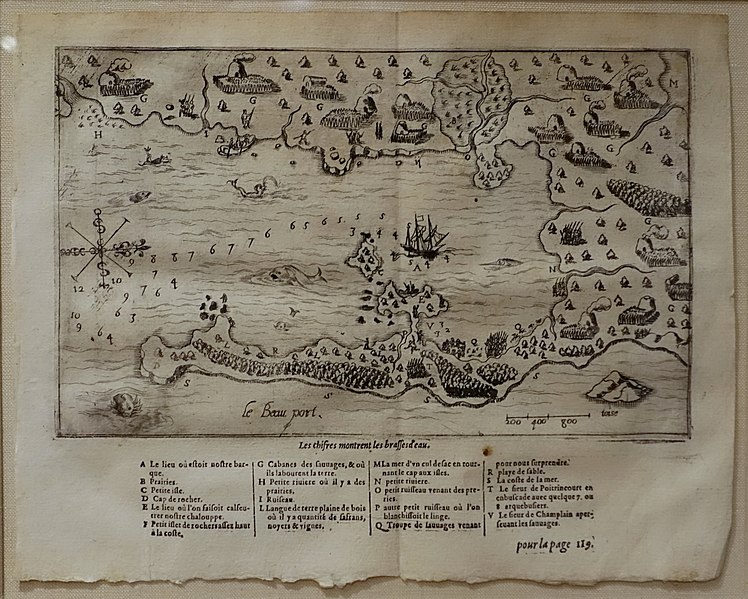
Gloucester’s modern colonization and settlement began in 1606 when famed French explorer and colonizer Samuel de Champlain came upon Cape Ann. Champlain was acting under King Henry the Fourth’s orders to establish a permanent French colony. While ultimately Champlain would settle farther north, he was taken with Cape Ann, naming it “Le Beau Port,” or “The Beautiful Harbor.”
File:Map of Gloucester Harbor (Le Beauport) by Samuel de Champlain, from Les Voyages, Paris, 1613 – Cape Ann Museum – Gloucester, MA – Public Domain
Recognizing the value in claiming this part of the North American continent, England began planning in earnest to establish settlements in Massachusetts. Captain John Smith, who gave New England its name, also explored Cape Ann’s coastline in his travels. He caught sight of three islands off Sandy Bay (now Rockport) and named them the three Turk’s Heads. These islands are Straitsmouth, Thatcher’s, and Milk Island. Turkey must have made a huge impression on him, because he named the Cape itself “Tragabigzanda” after a woman he’d met in Istanbul while a prisoner of war. English royalty approved of the New England Name, but Prince Charles decided to rename Tragabigzanda “Cape Anne” in honor of his mother, Queen Anne.
But what of the natives of Cape Ann, the Agawam tribe of the Algonquin people? At the time of European settlement, the Sagamore, or Chief, of the Agawam tribe was Masconomet.
I’m going to read some excerpts from Historic Ipswich’s 2021 article, “The Bones of Masconomet,” for the best information. I’ll link the article in the show notes. I highly recommend the Historic Ipswich blog for more information about Cape Ann’s neighbor to the North.
“When English settlers arrived at what was then known by the local Indians as Agawam, most of the tribe had already died from a plague brought by contact with Europeans. [As an aside, In my research, I have found it was assumed to be smallpox, and it was about 20 years before the following events, or sometime in the 1610’s.]
“On June 8, 1638 the last Sagamore (chief) of Agawam, Masconomet Quinakonant signed over all the land under his control to John Winthrop Jr., representative of the English settlers of Ipswich. The deed read as follows:
“I Masconomet, Sagamore of Agawam, do by these presents acknowledge to have received of Mr. John Winthrop the sum of £20, in full satisfaction of all the right, property, and claim I have, or ought to have, unto all the land, lying and being in the Bay of Agawam, alias Ipswich, being so called now by the English, as well as such land, as I formerly reserved unto my own use at Chebacco, as also all other land, belonging to me in these parts, Mr. Dummer’s farm excepted only;
“And I hereby relinquish all the right and interest I have unto all the havens, rivers, creeks, islands, huntings, and fishings, with all the woods, swamps, timber, and whatever else is, or may be, in or upon the said ground to me belonging: and I do hereby acknowledge to have received full satisfaction from the said John Winthrop for all former agreements, touching the premises and parts of them; and I do hereby bind myself to make good the aforesaid bargain and sale unto the said John Winthrop, his heirs and assigns for ever, and to secure him against the title and claim of all other Indians and natives whatsoever.
“Witness my hand, Masconomet, 8th of June, 1638.
“…Masconomet ruled all the tribal land from Cape Ann to the Merrimack River, which he sold to John Winthrop and the settlers of Ipswich for a sum of £20. The Sagamore died on March 6, 1658 and was buried along with his gun, tomahawk and other items on Sagamore Hill, formerly in the Hamlet section of Ipswich and now within the town of Hamilton. His wife is buried alongside him.
“On March 6, 1659 a young man named Robert Cross dug up the remains of the chief and carried his skull on a pole through Ipswich streets, an act for which Cross was imprisoned, sent to the stocks, then returned to prison until a fine was paid. He also had to rebury the skull and bones and build a two-foot-high pile of stones over the grave. His accomplice John Andrews was instructed to help and make a public acknowledgement of his wrongdoing.
“In Native American tradition the spirit of a person is called back when his grave is desecrated, and must roam the Earth looking for his bones. After the bones are found, a proper burial ceremony must be performed by his people before he can rest.
“In 1910, a stone was inscribed to mark the grave, and in 1971, a memorial service was held and a larger stone monument was erected, but it was not until 1993 that a ceremony with Native American rituals was conducted. After 355 years, Masconomet’s spirit was finally at peace. The final resting place of Masconomet is accessed by a paved road leading past the Sagamore Hill Solar Radar Observatory, and is graced with tokens of reverence.”
The first permanent settlement of the Massachusetts Bay Colony was established in 1623 at Fishermen’s Field, now known as Stage Fort Park, Cape Ann.
The reason it’s named “Stage Fort” is not absolutely concrete, at least the “stage” part. It’s likely because, in the 1600s, colonists used this large area of land abutting the harbor as a place to set up wooden stages to dry and preserve fish. The Fort part came a little later. If you come to visit, you can still see a grassy battlement with lovingly restored cannons, used in the Civil War, facing the Harbor. It was a working fort during conflict and in peacetime, from 1625 through the Spanish American War in 1898.
Although Gloucester was originally settled in 1623 as a fishing village, its residents decided to move a little further south to Salem, Massachusetts shortly afterward because it was not profitable. They came and went, mostly men working in the fishing and lumber industries, but they didn’t return here in numbers great enough to establish a town until 1642. At that time, the King of England allowed the settlers a grant, and the First Parish Church was established on Beacon Hill in what is now part of Downtown Gloucester.
Salem, MA, founded by Roger Conant and known in the colonial days as Naumkeag (named after the nearby indigenous Naumkeag village) was a bigger hub for trade and business than Boston was during the colonial times. Once fully established, Gloucester’s fishing and timber industries prospered while Salem, just 14 miles south by sail, enjoyed its time as the most influential city in Eastern Massachusetts.
Between 1640 and 1650, a total of 82 settlers came to Gloucester. A couple of the more locally-famous of these were Reverend Richard Blynman and midwife Isabel Babson.
If you’re familiar with Gloucester, you are undoubtedly acquainted with Stacy Boulevard, though that was built far after the colonial times. More than that, you know about the Blynman drawbridge, or the “Cut Bridge,” which splits the Boulevard roughly down the middle. The Blynman Bridge is named for Reverend Richard Blynman, from Marshfield, MA.
Cape Ann residents asked Reverend Blynman to come to Gloucester to lead the First Parish church in the 1640s. Blynman settled here with other parishioners from Plymouth County.
At this time, all Gloucester residents were obligated to attend church at the Meeting House on the Green, including the residents in West Gloucester. If this rule was violated, a resident could be prosecuted as a criminal. For example, John Kettle, a minor, was brought before Salem Court for breach of the Sabbath and for stealing.
The journey to the meetinghouse could be time-consuming and arduous. Those West Gloucester residents who did not live near the natural land bridge abutting Gloucester Harbor would have to take a ferry across the Annisquam River to reach the meetinghouse. That changed a few decades later, and I’ll do an episode on that.
Reverend Blynman was permited to dig a ditch connecting Gloucester Harbor to the Annisquam River, where he was granted land, in 1643. The town was given free rite of passage over the newly-installed bridge at “The Cut”, as it is still known. According to Babson’s History of Gloucester, published in 1860, Blynman was to “cut the beach through, and to maintain it, and to have the benefit of it to himself and his for ever, giving the inhabitants of the town free passage.” Blynman was obligated to maintain the bridge and the cut. As a reverend, he was not a popular man, though as a person, his parishioners and fellow townspeople were fond of him. He was pretty much run out of town sometime between 1649 and 1650 and, along with 13 other families, resettled in New London, Ct. Because of lack of financial resources, the town of Gloucester was without a minister until 1661. At that time, Reverend John Emerson was hired and a new meetinghouse was built roughly where Gloucester’s Grant Circle Rotary is now.
Because American colonial history is so intertwined with Puritan and Protestant histories, I will explore more in-depth figures such as John Murray, the founder of the First Universalist Church in America, at a later time.
Isabel Babson was a far more popular figure whose legacy lives on Cape Ann to this day. Please be warned: the following paragraph details a brief description of violence and miscarriage.
According to the Babson Historical Association, “Isabel Babson, when she arrived in Salem from Somersetshire in the southwest of England in 1637, was around 60 years old (no birth record exists to verify her birthdate). It is safe to assume that she was by that time a seasoned, expert midwife, who very likely trained younger women in the practice. Religiously, there was expectation that Puritan women as young as their mid-teens would be preparing for a fertile motherly career. This entailed the need for midwives. Good midwives were scarce in the colonies at that early time, and so Isabel Babson likely played an important role in her community in Gloucester. For this reason she was brought in as an “expert witness”, so to speak, (at the age of “about 80” in her own words) regarding a 1657 trial against a local man who was accused of causing a woman to miscarry a late pregnancy and almost lose her own life in the process. Isabel’s sworn deposition attested to the good character of the expectant mother, who had been accused of witchcraft, and described the brutal experience of childbirth that resulted in the death of the fetus and the severe trauma of the mother. “Mother Babson”, as she is referred to in the deposition, must have had a good reputation, such that an accusation of witchcraft would not touch her, as midwives were often accused of being witches themselves. Midwives were expert in preventing commonly fatal complications of childbirth, and Isabel’s description of how she and her team kept the mother alive attested to this expertise. Contrary to the Enlightenment expectation that midwives plied their trade as enchanted alchemists, they were in fact one of the most reliable and effective medical practitioners of early colonial New England. The best midwives could boast a successful record of thousands of healthy births and only a handful of injuries or deaths, even in such early modern times. It is no surprise that midwives were regarded as local leaders and legal authorities.”
If you come to visit Gloucester, be sure to check out the Isabel Babson Memorial Library on Main Street. It is dedicated to Isabel Babson’s memory and devoted to the topics of parenthood, maternity, and lifelong health and caregiving. I’ll include information about it in the show notes.
Where did Cape Ann’s settlers make their homes, though? For many, the interior of the island, an area known now as Dogtown, was where the oldest established settlement was built. There was readily-available fresh water thanks to springs. It was away from the harbor, which meant pirate attacks were less likely. And it was near the First Parish, the hub of the community. If you visit, stop by the Cape Ann Museum and buy a map of Dogtown. Make sure you bring your snacks, hiking boots, bug spray, and plenty of time. Don’t go alone; it’s easy to get lost. But treasures there include the famous Babson boulders along with numerous cellar foundations belonging to some of Gloucester’s true characters from antiquity. I’ll devote a whole episode to Dogtown, but for now, it’s time for me to sign off.
Please visit the BGW blog, bgreatwaters.com, for a transcript, pictures, and more info. That’s the letter b, then great waters, all one word.
If you feel so moved, please head over to my Patreon page: www.patreon.com/bgw. There you’ll find special perks for monthly supporters including merch. If you aren’t able to sign up for a Patreon at this time but would like to support BGW, please tell your family and friends about us, and if you can, leave a review in your podcast app. Reviews boost visibility for BGW, or really any other podcast you listen to, and us creators really appreciate it because it helps us bring you more content.
Thank you for listening, and thank you for your support.
Books:
History of the Town of Gloucester, Cape Ann, including the Town of Rockport: John J. Babson, c. 1860; republished 1972.
Gloucester, Massachusetts Historical Timeline: 1000 – 1999, compiled by Mary Ray, edited by Sarah V. Dunlap, assisted by Gloucester Archives Committee: Priscilla Anderson, Ann Banks, Stephanie Buck, Kathleen Cafasso, Lois Hamilton, Priscilla Kippen-Smith, Myron Markel, John Quinn, Alan Ray, Elaine Smogard, Janie Walsh, Natalie Whitmarsh. c. 2002, Mary Ray.
Good company in a journey makes the way seem shorter. — Izaak Walton
It seems Independence Day weekend is a good time to inaugurate the BGW Podcast and Blog. Thank you for joining me!
They that go down to the sea in ships, that do business in great waters; These see the works of the Lord, and his wonders in the deep.
So begins Psalm 107.
If you think of the city of Gloucester, Massachusetts, you might think of the world-famous Fisherman’s Memorial statue. Sculpted in 1925 by Leonard Craske, it exemplifies the tenacious spirit of the Gloucester fishing industry.The chances are good you’ve seen pictures of this dynamic bronze statue with the green patina, standing on a block of Cape Ann granite, even if you haven’t seen it in person. The fisherman, modeled after Gloucester captain Clayton Morrissey, stands at his ship’s wheel. He grips it with both hands as he stares down an oncoming storm, facing Gloucester Harbor, Dogbar Breakwater, and the Atlantic Ocean beyond.
Gloucester, with its four hundred years as America’s oldest sea port, boasts a wealth of history. Join us as we learn more about the untamed, authentic spirit of this community and its people. Thank you for listening to Business in Great Waters.