
Welcome to Business in Great Waters.
I am dedicating this episode to Helen Garland, who passed away earlier this week at the age of 95. She was an indomitable spirit and an incredible thinker who influenced and helped to improve the world locally and abroad, whether it was working with Margaret Mead or championing local causes such as the foundation of Awesome Gloucester – more on that in a little bit. Helen and her husband, author Joe Garland, who passed away in 2011, were the embodiment of the spirit of Gloucester. We are all grateful for, and better for, the vast legacies they have left.
Thanks to Robb F, Jeanine H, Brian K, and Edward K for your input on other TV shows and movies made in Gloucester – you helped me so much! These friends of mine told me the following: the very first episode of the show Route 66 was filmed here! 1998’s The Love Letter, starring Ellen DeGeneres and Tom Selleck, was filmed in Rockport. The Amazing Race started here one season. Scenes from the show Bewitched were filmed here. The Crucible, starring Daniel Day-Lewis, was filmed on Hog Island also known as Choate Island in Essex. And The Witches of Eastwick, starring Jack Nicholson, Cher, Susan Sarandon, and Michelle Pfeiffer was filmed in Ipswich at the Crane Estate.
Today, I’m going to focus on West Gloucester, the area west of the Annisquam River. I’m planning to do an episode or two of Magnolia soon, but today is just feeling like a West Gloucester day. Buckle up – this is likely going to be my longest episode yet.
INTERLUDE SHORT
Gloucester’s population usually hovers between 28,000-30,000, with more people being here in the summertime. The city is currently divided up into 5 municipal wards according to population, and further into 2 separate precincts per ward. The population in each precinct is calculated at a little less than 3,000 permanent residents each. West Gloucester is in Ward 5. It is precinct 2, sharing Ward 5 with Magnolia in Precinct 1. West Gloucester occupies the largest area of land in Gloucester. A huge amount of that is protected in the form of green space, watershed, or marshland. I love every part of Gloucester for different reasons, but I’m particularly keen on West Gloucester.
So if you remember, in Episode 2 I talked about land grants. 31 pieces of land in West Gloucester were deeded to Gloucester citizens in the 1600’s. You might also remember I talked about West Gloucester (and I’m assuming Magnolia) residents being obligated to take a ferry across the Annisquam to get to the meeting-house every week. According to the West Gloucester Trinitarian Church website, each resident had to pay a penny to cross, or two pennies if they came with a horse. If you are familiar with Gloucester, Ferry Street next to Addison Gilbert Hospital leads to a public landing. It was this public landing the residents of West Gloucester used to disembark from the ferry and trek the rest of the way to Meetinghouse Green.
Well, this got pretty tiresome, especially considering all the land at the residents’ disposal and the expense of the ferry toll. I turned to my trusty copy of Pringle’s History of Gloucester for the following brief information:
“In 1710 the inhabitants residing at the west parish petitioned the town for land in their precinct upon which to erect a meeting house. As has been shown, they were obliged to travel from three to five miles via the ferry to attend religious services. In March, 1716, they petitioned to be set off as the second parish and in June of the same year they were incorporated as such by the General Court. They erected a meeting house in a commanding spot and November 28, 1716, Rev. Samuel Tompson, of Newbury, a graduate of Harvard in 1710, was settled as their pastor. He married Hannah Norwood by whom he had several children and died December 8, 1724, aged 33. He was laid to rest in the old burial place of the parish…”
To elaborate further, Babson’s History of Gloucester reports on the first petition denial in 1710. ”The petition was referred to a committee of five to consider and report what was best to be done concerning it. They did not report in favor of the petitioners; but they made a recommendation, which was agreed to by the town, that the selectmen, in engaging a schoolmaster for the people of that section of the town, should endeavor to procure a man, who, in the judgment of their reverend pastor, was suitably qualified to preach to them on the Lord’s Day, for about three or four months in the winter season, in some convenient place to be designated by the inhabitants. The town voted to pay the schoolmaster out of the town-treasury, and to continue the arrangement three years.”
So the West Parish residents hired Samuel Tompson in 1712. They provided him with a salary, and he served them for another 4 years when another petition was filed, and then until his death. Reverend Tompson’s gravestone is now mounted on the wall at the West Gloucester Trinitarian Church along with other notable West Parish inhabitants. The parishioners continued to meet, and continue still, even after the old building finally needed to be taken down. The West Gloucester Trinitarian Congregational Church on Route 133 is the modern building and congregation continuing the West Parish traditions, including making a yearly trek to the old Second Parish site for a sermon – required for it to keep the charter valid.
Despite the establishment of the second parish, the ferry continued to run, as it saved time to cross the river rather than using the Cut bridge. But who ran the ferry? According to Babson, Samuel Hodgkins was hired to be the ferryman in July of 1694. According to all of my sources, the Hodgkins family ran the entire ferry operation for over a hundred years.
Although it has not been possible for quite some time to access the original Second Parish site by car or carriage, taking the 8/10 of a mile trail is a lovely and fairly easy hike. The area is run by the nonprofit Essex County Greenbelt. Here is their mission: “Greenbelt protects natural land and working farms across Essex County forever, helping to conserve healthy ecosystems, clean water, local food supplies, scenic landscapes and free, accessible places for all to benefit from nature.” Check out their website, ecga.org, in the show notes. It’s well worth visiting any or all of their properties.
What else makes West Gloucester unique?
An important West Gloucester story is that of Robin Freeman, a slave who bought his freedom from Captain Charles Byles.
Captain Byles was born in 1700. He lived in a home he’d purchased from his father on Essex Avenue (Route 133), which has since been lost to the ages. His family owned a tavern – Byles’ Tavern – right next to Beechbrook Cemetery, about 1/4 mile from state highway Route 128 and about 1/2 mile from the current Trinitarian Congregational Church. Captain Byles commanded a company during the French and Indian War at the Battle of Louisbourg in 1745. He also owned a slave named Robin or Robert Byles. The following information from Captain Byles’s account book is courtesy of the Cape Ann Museum archive: ”In 1768 or 1769, Robin [Freeman] bought his freedom from Captain Charles Byles (1700-1782), who concluded the financial negotiation in his account book with the words “Robing is free.” This refers either to the Robin Freeman who later appeared in the Joseph Moore (1763-1845) account book or to Robin Freeman the son of Prince and Robin Byles, who married in bondage in 1715. In his will of 1781, Byles left “Robin former negro servant 40s[hillings].” Captain Byles died in 1782.
The following information is from the Cape Ann Slavery and Abolition Project: Robert Freeman Sr. rented a home from another West Gloucester farmer and landowner, John Gotham Rogers, and raised his family there. Robert Freeman, Jr. went on to purchase and establish a family home at 302 Essex Avenue, where they lived for generations until the last member of the family, Harriet “Hattie” Johnson, passed away in 1931. The building was originally a sawmill built by Jacob Davis in 1709. It became a hostel and tavern where, rumor has it, a case of smallpox broke out because one guest was unwittingly carrying the virus in his hat. After Hattie Johnson passed away, the building was by turns The Stagecoach Inn and a private home. The house is now the headquarters of Wellspring, a nonprofit agency serving families and adults on the North Shore, helping them to achieve employment and financial security through stable housing, education, job training and career readiness. Check out the Wellspring House website in the show notes.
Across the street, there’s a Little Free Library – founded by myself with support from the neighborhood, our local hardware store The Building Center, the Gloucester High School vocational program, the City of Gloucester, and an Awesome Gloucester grant – a picnic area, and a public landing named after shellfish warden Stubby Knowles. More on him in a minute. It’s very pleasant to stop and sit a spell, especially if you feel like grabbing an ice cream or a cold drink from the convenience store across the street. Awesome Gloucester is a chapter of the Awesome Foundation, and encourages and supports projects intended to add Awesomeness to Gloucester in any of the following areas: (1) innovation in maritime related industry and economy, (2) preservation of maritime heritage and culture, and (3) community togetherness and appreciation. Helen Garland helped found the Gloucester chapter of the Awesome Foundation. To date, they have awarded $138,000 in micro grants to over 125 worthy causes. I’ll leave a link to their page – and to the Building Center – in the show notes.
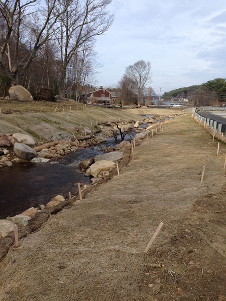
Right behind the Freeman House, as it is still affectionately known, there is a pleasant, babbling brook. It is called Alewife Brook, and it is next to the water treatment plant at the corner of Magnolia Ave and Essex Ave. The public is free to visit this site. Parking behind the plant can be a little tricky, but it’s worth the reward. You can sit or stand and observe the brook on a platform built by a local Eagle Scout. You can see where the alewife counters observe the fish swimming upstream to spawn starting April 1. But it didn’t look this way for decades.
Back in the 1960’s, Gloucester shellfish warden, West Gloucester Native, and tremendous environmental steward, Stubby Knowles, emphasized the importance of installing a fish ladder when the original water treatment plant was built to replace the pumping station. The plant was built right over the old stream in 1969, and Stubby was adamant that a fish ladder be built to help preserve the herring population who spawn at the Lily Pond off Laurel St. There was little to no knowledge of how to build an artificial fish ladder to replicate what the fish had been using in nature for millennia, so the City built the next-best thing – one made of concrete slabs. It was better than nothing, but it provided no protection from the elements and no place for the fish to rest. At least it was there! 46 years passed between the construction of the fish ladder and when the brook was restored.
Dozens of people have been doing the fish counts, here and in other areas around Essex County, for decades. Because of their tireless work, the city of Gloucester was able to partner with NOAA, the National Oceanic and Atmospheric Administration, and also secured funding from the City’s Community Preservation Committee, to create this beautiful fish ladder and habitat. Now the alewife have a natural stream to make their run to the Lily Pond and mate, and then swim back down the brook to Little River, the tidal river which feeds into the Annisquam. This would have been far more difficult to achieve if it had not been for Stubby Knowles’s advocacy. Now, the food chain is stronger, our landscape is even more beautiful, and we’ve gained a deeper understanding of environmental science and stewardship we can learn and teach our children. Please see the show notes for a link to the PDF application of the Little River fish ladder restoration project, including images and important data.
Want to get around West Gloucester but aren’t sure where to start? By vehicle or by bike, you could try out The Little Heater.
What the heck is that? According to Gloucester lore, it is more or less a scalene triangle consisting of major roads surrounding land including Ravenswood Park, Fernwood Lake and some smaller bodies of water, and Bond Hill. Bond Hill is a small hill with a reservoir and some homes abutting Ravenswood Park. Fernwood Lake had an historic ice house back in the days before electricity. I’ll talk about Ravenswood shortly.
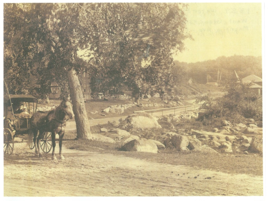
According to celebrated local historian and author Joseph Garland in his book “The Gloucester Guide: A Retrospective Ramble” published in 1973 for Gloucester’s 350th anniversary, “The junction of Magnolia and Western avenues was one corner of ‘The Little Heater,’ when the hoss was boss, a rough triangle of three roads which was far and away the most popular drive for the smart turnouts, carriages, buggies, pacers, teams, matched pairs and horseback riders of the resort era. No one is quite sure how Magnolia Avenue to Essex Avenue at Little River to Western Avenue at Kent Circle and back to Magnolia Avenue, or the reverse, got its name. Some say because it warmed up your horses, others because it was shaped like a snowplow called a heater, others because it resembled in outline a chunk of cast iron, a heater, which the housewife heated on the stove before dropping it in the hollow of her flatiron, and still others because it was a ‘heat’ for the gents who savored racing their fast trotters around it. There was a ‘Big Heater,’ too, a longer trot along Essex Avenue to Essex, south on Southern Avenue and School Street to Manchester, returning to Kent Circle by Magnolia Avenue.”
This rough triangle’s apex is at the corner of Essex Avenue and Magnolia Avenue, right next to the Freeman House. If you travel south down Route 133, you’ll come to Kent Circle at Stacy Boulevard. Consider, though, stopping at the Causeway or the Cape Ann Marina for lunch, White Farms for ice cream, and a movie at Gloucester Cinema.
Kent Circle is the intersection of Route 133 and Stacy Boulevard, the second corner of the triangle. You’ll pass Stage Fort Park (or, if you want to go through it, turn left at the baseball field onto Hough [pronounced “Huff”] Avenue). Keep going, following Western Avenue, passing landmarks along the way. Which landmarks? On the left, on a hill and behind a fence, is the Cardinal Cushing estate. The Boston Archdiocese unwittingly sold it to the Unification Church – yes, the “Moonies” – through an intermediary in the late 1970’s. You can bet I’ll expand on that topic in a future episode!
Further down on the left, you might catch a glimpse of Freshwater Cove and Dolliver’s Neck through the trees. This area marks the entrance to Gloucester Harbor on the Southwest side and is simply stunning, dotted with stately private homes and marsh land. Across the street on the right, you’ll pass a shoulder where you might stop to gaze at Buswell Pond. This pretty body of water is privately owned, so please no swimming, boating, etc.
Staying on Western Avenue, you’ll drive by several very old homes. Now, this is not to say there are not other old homes along this route. I’ll get into as many old homes as I can during this series. However, I always find myself paying more attention to the homes along this end of Western Avenue because of all the hustle and bustle that’s usually happening near the Boulevard. Please also note, unless otherwise specified, these are private homes. I just find them so intriguing, especially if they happen to have a historic plaque with the name of the original owner!
Further up on the right, you’ll eventually happen upon Ravenswood Park. The Trustees of Reservations own this immense property, 600 acres in all, with trails in the woods, hills, swamps, deciduous and evergreen trees, granite boulders, and sweeping views of the harbor. Samuel Sawyer, a local philanthropist, purchased the land and bequeathed it to the City, and the Trustees purchased it in 1993. The Trustees write: “Ravenswood Park offers 600 acres for solitude and quiet contemplation, a testament to its founder’s conservationist philosophy. Nineteenth-century businessman and philanthropist Samuel Sawyer purchased woodlots, old pastures, and swamp near his home on Freshwater Cove, and upon his death left the more than 26 parcels to be turned into a park named Ravenswood, after the castle in Sir Walter Scott’s The Bride of Lammermoor. Whether you prefer to surround yourself with snow-covered hemlocks, experience spring emerging in a burst of color and aroma, or escape the summer heat, you’ll find refuge here.”
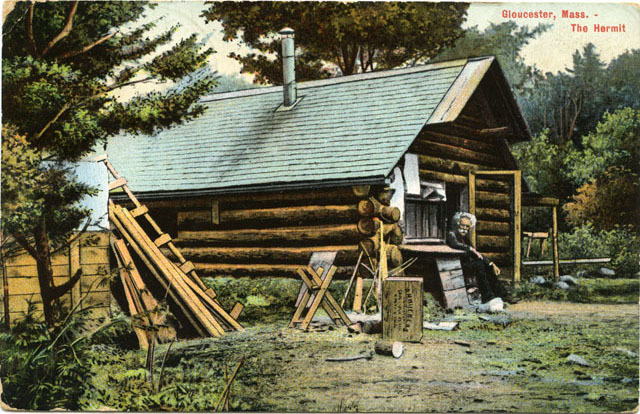
Another fascinating character of West Gloucester was Mason A. Walton, the Hermit of Ravenswood.
After the tremendous personal loss of his wife in childbirth followed by the baby a few hours later, Walton went to work in Boston but developed a severe respiratory infection. He decided to move to Gloucester, where he built a cabin at Ravenswood in 1884 and, giving Henry David Thoreau a run for his money, commenced spending many years studying the wildlife there. He wrote several books, including “The Hermit’s Wild Friends, or 18 Years in the Woods.” He was also a writer for Field and Stream magazine and attracted thousands of visitors a year to the hermitage. Unfortunately, his home burned to the ground in the late 1940’s. There is still a tablet at Ravenswood denoting where he lived, placed there in 1933 by the Gloucester Women’s Club. Check out the blog, where you can see a vintage postcard picture of Walton at his house courtesy of the Sawyer Free Library Digital Heritage site.
Once you leave Ravenswood, continue on Western Avenue. There are walking paths everywhere maintained by the Cape Ann Trail Stewards, a volunteer-run coalition of Cape Ann residents, and there are ways to get from Ravenswood all the way to the shoreline if you plan ahead of time. But back to the Little Heater: If you visit at the right time, you’ll see the gates at the soccer fields are open. These fields are actually capped landfills. Please park in the designated parking areas and take in the gorgeous view – but be mindful of the Canada geese and their droppings.
Keep going. You’ll see woods, houses new and old, another baseball field, and then it’s time to turn right onto Magnolia Avenue. You’ve made it to the third corner of the Little Heater!
Magnolia Avenue is primarily residential, athough there is access to the Kondelin Road Industrial Park from it. Watch out: in the wintertime, because of its proximity to the swamp, the road can become choked with ice and is thickly settled in places. Depending on where you are on the road and the time of year, it is possible to see the Lily Pond and the MBTA train tracks down the hill on the left as you make your way back to Route 133.
Eventually, you’ll go under a train bridge. Keep going, and you’ll find yourself back at the water treatment plant! That was a fun journey.
There is still so much I want to tell you, but that will come another time. Right now, it’s time for Not-So-Clear Facts.
TRIVIA
Before 1623: the Native American name for Cape Ann was Wingaersheek.
1704 – 1705: Landlady Judkins was paid for entertaining town fathers. I’m assuming at a tavern.
1716: there was a great darkness, and the air was filled with smoke.
In 1836, a shoe dealership was established.
1919: First municipal garbage collection.
1963: 2 earthquakes at sea jolted Cape Ann
OUTRO
Please visit the BGW blog, bgreatwaters.com, for a transcript, pictures, and more info. That’s the letter b, then great waters, all one word.
If you feel so moved, please head over to my Patreon page: www.patreon.com/bgw. There you’ll find special perks for monthly supporters including merch. If you aren’t able to sign up for a Patreon at this time but would like to support BGW, please tell your family and friends about us, and if you can, leave a positive review in your podcast app. Positive reviews boost visibility for BGW, or any other podcast you listen to, and us creators really appreciate it because it helps us bring you more content.
Thank you for your support.
Books:
History of the Town of Gloucester, Cape Ann, including the Town of Rockport; John J. Babson, c. 1860; republished 1972
The Gloucester Guide: A Retrospective Ramble; Joseph E. Garland, c. 1973
History of the Town and City of Gloucester, Cape Ann, Massachusetts; James R. Pringle, c. 1892
Gloucester, Massachusetts Historical Timeline: 1000 – 1999, compiled by Mary Ray, edited by Sarah V. Dunlap, assisted by Gloucester Archives Committee: Priscilla Anderson, Ann Banks, Stephanie Buck, Kathleen Cafasso, Lois Hamilton, Priscilla Kippen-Smith, Myron Markel, John Quinn, Alan Ray, Elaine Smogard, Janie Walsh, Natalie Whitmarsh. c. 2002, Mary Ray.
https://www.wgtccucc.org/about
https://www.wgtccucc.org/history
https://www.wgtccucc.org/more-history
https://ecga.org/Property/Tompson-Street-Reservation
https://www.gloucester-ma.gov/DocumentCenter/View/759/CDD-Little-River-2011-CPA-Application?bidId=
https://www.hermitary.com/articles/walton.html
https://digitalheritage.noblenet.org/noble/items/show/938
